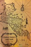
Central America Early Maps
Capt. K. S. Kapp
A spirited curiosity and a fascination for Central America has inspired the author to conduct research and travel into remote parts of this land, to explore the coast and direct hydrographic surveys in the Bay Islands and off the Mosquito coast. This bibliography is intended to list, as completely as possible, the printed general maps of Central America, including detailed ...
a disponibilidad
Sinopsis
A spirited curiosity and a fascination for Central America has inspired the author to conduct research and travel into remote parts of this land, to explore the coast and direct hydrographic surveys in the Bay Islands and off the Mosquito coast.
This bibliography is intended to list, as completely as possible, the printed general maps of Central America, including detailed plans of Costa Rica, Nicaragua, Honduras, Salvador, Guatemala, British Honduras and Yucatan.
Geographically, Central America extends from the isthmus of Darien, where ir connects with South America, to an undefined line somewhere between the Tropic of Cancer and the present United States -Mexico border. Maps featuring Panama are described in a previous publication "The Early Maps of Panama up to 1865", while Mexico and specific plans of its provinces will be presented in a forthcoming work by the author.
Comentarios
Sé el primero en comentar este libroArtículos relacionados